Jack Day's
 Worlds: A Veteran's Experience

Return to Vietnam 2004
3. Kontum, Dak To, Ben Het
On Thursday evening the veterans group from the Mekong met the non-veterans, who had arrived in Saigon, and on Friday morning we all boarded an Air Vietnam plane bound for Pleiku. We landed on what I assume was the same runway in use in 1969, but the civilian terminal was modern and new, and nothing looked familiar. We would return to Pleiku, but for now our new bus headed north to Kontum.

From 35 years before, I had mental pictures of Route 14 going north from Pleiku to Kontum and Dak To. The road seemed about right, but surrounding it? Gone were the wide areas on either side where the vegetation had been cut out; gone were the tanks guarding the road at intervals. Now the vegetation had grown back and there were trees, and the empty spaces were being filled with houses as Vietnamese no longer had to worry about areas that were insecure.

The hillsides seen from the road, on the other hand, often had less vegetation, the result of deforestation. Areas that before had been abandoned now showed signs of crops.

Before long we arrived in Kontum. This square was on the north shore of the Dak Bla River. The long Route 14 bridge over the Dak Bla approaches the square from the bottom left corner of the picture.

In the square was this memorial. In areas where there had been heavy fighting, there now are numerous memorials to the heroism of the victors. (As is usually the case following wars, the sacrifices of the vanquished go unremembered.) Our hotel was to the right of this square. We checked in, had lunch, and then proceeded on up Route 14 to Tan Canh in the Dak To District.

A section of Kontum had a brand new boulevard.

It was always interesting to speculate on the meaning of the many posters on the highway.

The main square in Tan Canh (Dak To town) is at the intersection where Route 14 continued north and 522 split off to the west. Like most other squares in Vietnam, it now has a monument.
We proceeded west on 522 and stopped where there was an abandoned airstrip on the left. This must have been where the First Brigade headquarters had been. Unfortunately there were signs forbidding photography, so we took photos. The previous year, however, Steve Edmunds, who had been with the 3d Bn, 8th Infantry, one of my units, visited there and had this photo taken on the Dak To airstrip with his family.

Steve Edmunds family at Dak To, 2003: Elsie, Jennifer, Steve. The photographer is facing east. Used by permission.
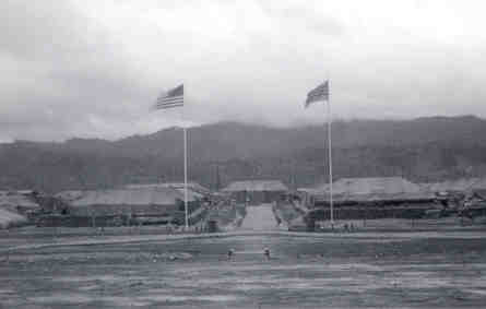 Standing on the airstrip and facing the mountains, once called Rocket Ridge, I recalled the photo, left, of the First Brigade Base Camp that I had taken 35 years before, facing south. I pointed out to the others where Firebase 5 and Firebase 6 had been, at the two ends of the ridge behind the base camp, and described the bustle of helicopters moving from our area up to these and other firebases in the area. Of all the places I had been in that long-ago year, somehow the feeling I had for this place called Dak To was the most intense. It was my first duty assignment in the war. It was the place I left from and returned to from visiting troops on isolated mountaintops. It was the first place I knew physical danger; it was no accident we slept in underground bunkers. And it had the surreal beauty of mountains that challenged logistics and sudden mists closing our links to each other that demonstrated nature too was a player in this struggle for mastery. We lit incense to honor all who had died in the area of this abandoned airstrip once used by American planes and helicopters.
We continued west on 522, crossing a bridge which I was sure had been bombed and impassable 35 years ago. We came to a new Vietnamese town in an area that had been uninhabited, dangerous territory 35 years ago. Then the Ho Chi Minh trail had gone through this area and it was often contested.

The tour group visits the main intersection of the new town on the Ho Chi Minh Trail, now Ho Chi Minh Highway. Looking north. Bob Moore photo.

Across the road is a pavilion. Notice the dragon on the corner of the roofs; the lines of the roof point up in Chinese fashion so that any devils landing on the roof will be directed back up into the sky. A Vietnamese flag is on the roof and mountains in the background. Looking East. Ed Tich photo.

An historical plaque in Vietnamese commemorates the Ho Chi Minh Trail during war time. At the bottom one sees the words "My" for American (literally it means "beautiful"), and "Nguy", an insulting term meaning puppet (referring to the South Vietnamese army.) Tom Greving photo.

Now at least this portion of the Ho Chi Minh trail has been paved and in the town it has four lanes, with a street sign identifying it as the Ho Chi Minh Highway. Tom Greving photo.

With the edge of the sign to the left, we look across the Ho Chi Minh Highway northeast to the mountains. Ed Tich photo.
Farther west we came to our destination, the remains of the Ben Het Special Forces Camp. Not much farther west is the border with Laos. You could see where the airstrip had been; vegetation had not yet conquered it. Someone had an aerial photo of the old camp, built on a hillside; we walked the hillside imagining what had once been. It had been a long day, and daylight was fading. Later I wrote Ben Het at Dusk.

Bob Moore took this photo of a marker commemorating the Ho Chi Minh trail. The broken pavement to the right goes through the center of what was the Ben Het Special Forces camp.

At the sites we visit there are very very few signs that there were military here 35 years ago. But here we see the remains of a sandbag, and the sole of a jungle boot. Bob Moore photo.

The trail that goes through the Ben Het site proceeds westward. Looking westward, we see a Montagnard family approaching the group. It looks like they have been collecting firewood. Bob Moore photo.

After passing us. the Montagnard family continues eastward through the Ben Het site.
We drove back to Kontum in the dark. 35 years ago, the dark belonged to the enemy.

The next morning I walked to the square in Kontum and took this photo of the monument. Then we drove south, returning to Pleiku.

The nearby river is peaceful now. Ed Tich photo.
<------ Mekong Delta |
Pleiku------>
Home Page |
Veteran |
Vietnam |
VVAW |
VVA |
NCVNVM
Return |
Ho Chi Minh City |
Mekong Delta |
Kontum, Dak To, Ben Het |
Pleiku
Danang |
Hue |
DMZ and environs |
Hanoi and Ha Long Bay |
Album |
Poetry |
Sign Guestbook |
View Guestbook
Updated July 30, 2004